
Tactical Operating Environment

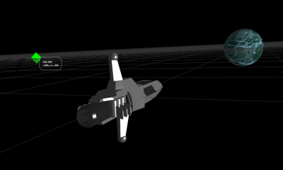
The Tactical Operating Environment (TOE) is the area of space surrounding the vessel that requires active management, due to possible navigational hazards or tactical threats. The TOE is loosely defined by the range of tactical sensors, which locate and track non-mapped objects.
Maintaining the TOE is the primary task of the vessel’s tactical team. This includes detection and tracking of unmapped objects around the vessel and if necessary developing firing solutions to any object deemed a threat to the vessel’s safety.
Depending on environmental conditions, the TOE extends to a radius of approximately 15 million kilometres.
TOE Grid
 The TOE grid represents the vessel’s operating environment. It displays all mapped astronomical objects such as stars, planets, moons and other major bodies, as well as any mapped man-made objects such as space-stations.
The TOE grid also displays any other objects detected by sensors and deemed to be of significance to the vessel’s operation (see TSMOs below).
The grid is oriented to the orbital plane of the star system currently being navigated.
TSMOs
Tactically Significant or Maneuvering Objects (TSMOs, pronounced sumo) are un-mapped objects detected in the vessel’s operating environment that are of tactical significance.
All maneuvering objects – objects capable of altering their own course - are of tactical significance because it is assumed that a maneuvering object is of artificial construction and therefore a vessel of some kind. Naturally occurring objects that are capable of maneuvering are extremely rare.
TSMOs are detected by EMDAR (see below) and designated as a 'track' (tracked contact) if considered significant. Once tracked, the TSMO is displayed on the TOE grid for as long as detection is maintained (or if the TSMO is undesignated).
Fixed objects or those with defined movement (such as an orbit) may also be of tactical significance either because they may represent a possible threat - such as a weapons or sensor platform (in the case of a satellite or unmapped space station) - or because they may provide cover from detection.
Detection
The goal of tactical sensor systems is to detect a threat TSMO before it can achieve counter-detection, without giving away the location of the vessel in the process.
EMDAR
Electro-Magnetic Direction and Ranging (EMDAR) is a passive sensor technology that detects emissions along the EM spectrum to identify and track other vessels. The system is passive because it does not emit any EM to make its detection (compared to RADAR which emits radio waves to achieve detection). Instead, the system detects EM radiation falling onto its sensors and calculates likely distance using dispersal patterns, a process similar to SONAR.
The advantage of the passive system is that it does not provide any EM emission for an opposing vessel to detect. The disadvantage is that passive systems can only achieve relatively weak readings, sometimes difficult to distinguish from background radiation. Dispersal patterns also become increasingly less predictable over distance, making range estimations less certain.
The EMDAR detection process is therefore as much an art as it is a science. It requires an operator to spot patterns across multiple windows and make accurate estimates as to whether that pattern is a vessel (TSMO). If it is, then estimates as to range, heading and speed will be needed to help the commanding officer make tactical decisions.
Contacts
If a TSMO is detected, the EMDAR crew will declare a contact to the bridge along with whatever information they can provide such as heading, range, maneuvering patterns, etc.
The commanding officer will choose a designation for the contact.
A designated contact will appear on the Contact Board along with range and bearing to its last identified location. This location is a point in space that represents where the crew thinks the contact is likely to be. At this stage vessel systems are not receiving data directly from the contact itself. The location will therefore need to be manually updated periodically by crew to account for vessel and/or contact movement.
Tracking
The crew will then work to refine the contact's suspected location until the crew identifies its actual location. Until they do this, a contact cannot be targeted by weapons systems.
Narrowband EMDAR sensors which can be trained on specific points in space are capable of directly analysing the EM emissions of an object in that area of space. This direct analysis allows these sensors to maintain contact with the contact as either it or the vessel moves, providing continuous updates on the contact's actual location.
If trained on an area of space that contains a contact, the narrowband sensors will continuously track the contact, which is now referred to as a tracked contact (or "track").
Targeting
Once a TSMO's location is being tracked by sensors, it can be targeted by weapons systems.
Firing Solutions
A firing solution consists of information necessary to guide a torpedo to a contact if the need arises. This includes the TSMO’s bearing and its estimated speed and heading, as well as a definition of the search area the torpedo will use once it goes active.
This data only becomes a firing solution when the estimates are considered accurate enough to ensure a reasonable chance of a successful hit. This is determined by factors such as the strength of the EMDAR detection profile, range and the relative speed of the target and vessel.


